WHAT IT IS
Troposcatter (tropospheric scatter) is beyond-line-of-sight radio that uses the lowest layer of the atmosphere as a weak, always-on mirror. Two terminals point high-gain microwave dishes at the same patch of turbulent air, typically 1–15 km up. A tiny fraction of the energy — tens of decibels down, often 60–90 dB of the incident power — is redirected forward by irregularities in refractive index. The far terminal, over the radio horizon, recovers that smear. No satellite. No ionospheric hop. No cable.
The working band in fielded systems is roughly 350 MHz to about 8 GHz, with the practical military/civil peak around 900 MHz, 2 GHz, and 4.4–5.0 GHz. Below ~1 GHz some of the energy is closer to layer reflection than pure turbulent scatter; above ~10 GHz rain and oxygen eat the path. A hop is commonly 80–250 km on tactical sets, 300–500 km on large fixed billboards, with published extremes past 1,000 km on cold-war strategic links that spent megawatts and 20–30 m antennas to buy the last kilometres.
It is not HF skywave (F-layer, 3–30 MHz, day/night MUF). It is not tropospheric ducting (a weather bonus that can make VHF go hundreds of kilometres on a good inversion). It is not meteor-burst (E-region ionization lasting tenths of a second). The scatter volume is always there. The price is power, antenna gain, and a modem that can live with Rayleigh fading several times a minute.
HOW IT WORKS
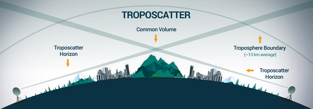
The troposphere is wet, turbulent air. Temperature, humidity and pressure blobs a few metres to tens of metres across produce tiny changes in refractive index. A narrow microwave beam crossing that weather is scattered. Most of the energy keeps going. A forward lobe is usable if both antennas illuminate the same common volume — the intersection of the two beams just above the radio horizon.
Geometry is the design. Take-off angle at each end is a few degrees above the local horizon, sometimes even a hair below on an elevated site. The scatter angle (the angle between the two beam axes at the common volume) sets loss: a larger angle, a longer hop or a blocked horizon, costs decibels fast. Path-loss models (NBS / ITU tropo, Yeh, Collins, later turbulent-spectrum fits) treat that angle, frequency (~30 log f in several formulas), antenna beamwidth, and climate. The channel is a lossy waveguide. Coherence bandwidth on a 250 km, 4.7 GHz, 3 m-dish example has been calculated near ~2 MHz at 50% correlation — which is why analog FM multiplex of the 1960s and fat digital carriers of the 2020s both fight delay spread.
Two fades live on the path. Fast fade (Rayleigh, many times per minute, >20 dB) is multipath inside the common volume. Slow fade is weather and the daily structure of the tropopause. Availability numbers quoted for engineered links are in the 99–99.9% class — bought with diversity, not with hope.
Diversity is not optional. Classic quadruple diversity: two dishes several metres apart (space) and two polarizations or two frequencies (H/V or Δf). Frequency spacing on a 4.7 GHz / 250 km / 3 m example is on the order of 10–15 MHz in ITU-style rules. Angle diversity (two feeds slightly offset on one dish) appears on later tactical sets. Modern software-defined tropo modems add adaptive coding and modulation (ACM) that change constellation and FEC frame-by-frame as the smear breathes. That is how a 1980s 2 Mbit/s TRC-170 path becomes a 20–210 Mbit/s path on the same sky.
A link is two terminals looking at each other. There is no hub in the sky. Relay chains (10 hops × 200 km = 2,000 km on some Warsaw Pact “Bars” planning figures) are just more common volumes in a row. Power at the feed: tens of watts on a light civil set, 220 W–1.5 kW on Soviet/Russian tactical tropo, 500 W–1 kW SSPA on current Comtech MTTS cases, many kilowatts on White Alice billboards.
WHAT IT IS USED FOR
Wherever a staff wants a fat, private pipe over terrain that will not take a microwave tower line and will not be trusted to a leased bird.
Strategic / early-warning backbone (1950s–70s). Radar nets above the Arctic tree line. White Alice, DEW / Mid-Canada, Pole Vault, NATO ACE High, North Atlantic Radio System, Soviet TRRL “Sever” along the Arctic and Pacific coasts and the great Siberian rivers. Those were the billboard farms: 9–30 m dishes, hundreds of voice channels, built because HF faded and satellites did not exist yet.
Operational / army field network. Divisional and army hops of 100–250 km when SATCOM is jammed, denied, or not allocated. Soviet/Russian R-408 Baklan through R-423 Brig and R-444 Eshelon; U.S. AN/TRC-97, AN/TRC-170, now Comtech COMET / MTTS / NGT; Chinese CETC TS-504 / TS-510 on IADS and HQ-9/S-300 batteries; Belarus Gorizont. Ukraine 2022–26 still kills R-423-class shelters and mislabels R-416 line-of-sight relays as tropo.
Civil and disaster. Oil, Arctic, mountains, islands, hurricane restoral. Groza-1.5 is sold exactly that way: two 70 kg cabinets and two 1.5 m dishes, no spacecraft rent. Western MTTS datasheets list disaster recovery in the same sentence as tactical BLOS. Polar coverage is a selling point GEO SATCOM does not have.
What it is bad at. On-the-move at highway speed (research “tropo-on-the-move” exists; it is not a jeep radio). Single-terminal broadcast to many random subscribers (it is a point-to-point or point-to-few engineered path). Video to a million phones (Starlink’s job). A 1.5–3 m dish in 80-knot leftover hurricane wind without guys.
CAPABILITIES (ORDER OF MAGNITUDE)
These are published bands, not a guarantee on a given Tuesday.
Range. Light / civil portable: 50–210 km advertised (Groza-1.5). Tactical digital: 100–250 km typical, Comtech Florida trials 193 km at 87 Mbit/s and 257 km at 41.5 Mbit/s on MTTS. Heavy fixed: 300–500 km common, strategic hops above 1,000 km with giant antennas. Scatter angle and horizon blockage dominate; a mountain in the first Fresnel of the take-off ruins a brochure number.
Rate. Analog era: tens to ~132 voice channels (White Alice multiplex). Early digital tactical: 64 kbit/s–2 Mbit/s (R-423-1 64 kbit/s @ 230 km or 2 Mbit/s @ 150 km; TRC-170 class ~2 Mbit/s before modem upgrades). Current software-defined: Groza tropo mode 25 → 45.5 → trial 49.9 Mbit/s; Groza radio-relay mode quoted to 155 Mbit/s when the path is actually LOS. Comtech CS67PLUS / MTTS PLUS: single stream to ~105 Mbit/s, dual stream to ~210 Mbit/s, 4.4–5.0 GHz, 500 W or 1 kW SSPA, ACM. Those 200 Mbit/s figures are dual-stream on a cooperative path, not a promise at 250 km in rain.
Latency. Speed of light plus modem interleave. Milliseconds to tens of milliseconds — SATCOM GEO’s 250 ms it is not. Useful for voice, C2, UAV backhaul at staff range.
Detectability / EW. Narrow beam, low elevation, complex waveform. Harder to find than an omni HF net or a VSAT staring at a known GEO slot. Not invisible. A tropo terminal is still a microwave emitter with a dish.
Availability. Engineered quad-diversity analog links were built to 99.98% class (minutes per month). Digital ACM trades rate for stay-up. Weather, rain at C-band, and a mis-aimed dish are the real outages.
HISTORY
Physics papers on beyond-horizon VHF/UHF pile up from the late 1940s. Booker–Gordon turbulent scatter is the usual theoretical ancestor. ITT’s Nutley, N.J.–Southampton, Ontario link in 1955 is cited as the first operational tropo circuit. Bell Labs / Lincoln Laboratory work for the Pinetree radars produced field tests in Newfoundland (~150 miles, conveniently one radar spacing).
Pole Vault (1954–55). First long-distance tropo route. Amended onto the Pinetree comms contract in January 1954; six initial stations commissioned February 1955, Pepperrell, Newfoundland toward Frobisher. Microwave tower lines were abandoned mid-build. That speed of fielding set the Cold War pattern: tropo is what you use when the radar net is already pouring concrete and the horizon is in the way.
White Alice (WACS), 1955–58 dedicated, died ~1979. USAF / Western Electric / AT&T. Alaska: originally ~25 tropo stations, later on the order of 49–80 sites depending how one counts microwave tails. ~3,000 route miles. 4–5.5 GHz, space + frequency diversity, up to 132 voice channels. 30 ft and 60 ft dishes; alignment specified to a fraction of a degree because a 100-ton billboard does not get re-aimed. Cost figures in the open run $140 million for the first 25 tropo sites and $250 million-class for the fuller system. Tied DEW, BMEWS, and civil Alaska together until RCA SATCOM made the billboards museum pieces. Turned over to RCA in 1969; satellite cutover 1979.
Same decade: Mid-Canada and DEW tropo tails, North Atlantic Radio System in the GIUK gap, NATO ACE High across Europe and the Atlantic. Netherlands TNO ran 150 MHz experiments to Norway (1956) and army tropo trials into the mid-1960s. Everyone with an Arctic or Alpine radar wanted the same box.
TRRL “Sever” (USSR). From the mid-1960s, a strategic tropo radio-relay line more than 13,000 km along the Arctic and Pacific coasts and the Ob, Yenisei and Lena. About 46 stations by ~1970. Equipment lineage “Gorizont” / Gorizont-M (not the later Belarus tactical Gorizont). 20×20 m and 30×30 m billboards. Same job as White Alice: the North does not have a mountain-ridge microwave path. A 1982 Indo-Soviet stamp commemorates a Srinagar–Dangara tropo hop. Warsaw Pact “Bars” automation in the 1980s chained Baget-S / Atlet-DS tropo across six member states.
Tactical generation, 1960s–80s. Sets shrink from buildings to trucks. U.S. AN/TRC-97, later Raytheon AN/TRC-170 (4.4–5.0 GHz digital, V1/V2/V3 configurations still in the inventory and modem-upgraded toward 20 Mbit/s). Soviet MNIRTI line: R-408 Baklan, R-410 / R-410-5.5 / R-410-7.5 Atlet, R-412 Torf, R-417 Baget, R-420 Atlet-D, R-423-1 Brig (1981) and R-423-2A, R-444 Eshelon. Brig is the two-mesh-dish-on-shelter silhouette. China fields TS-504 / TS-510. Analog multiplex gives way to 64 kbit/s–2 Mbit/s PCM.
Satellite winter, 1975–2000. GEO leases are cheaper than 60-foot steel. Fixed tropo farms go cold. Tactical tropo survives in doctrine as the SATCOM backup and the polar/jammed-bird path, then sits in depots.
Digital revival, 2010s–2020s. Peer-war SATCOM jamming and LEO dependence pulled tropo back onto the price list. Comtech CS67PLUS software-defined tropo radio, COMET light terminals, MTTS / MTTS PLUS transit-case 500 W–1 kW systems, U.S. NGT / BLOS-T / DART-T family names. Florida 2022 trial numbers (COMET 44 km / 210 Mbit/s and 72 km / 16 Mbit/s; MTTS 193 km / 87 Mbit/s and 257 km / 41.5 Mbit/s) are the brochure that sells NATO staffs. Spectra Group €13 million MTTS contract for a NATO ally, announced September 2026. Russia: MNIRTI compact “Ladya”; NPP Radiosvyaz / Roselektronika Groza / Groza-1.5 (1.5 m dish on tripod or mast, ~70 kg cabinet, neural-net modem, 2024 deliveries at 45.5 Mbit/s, Yamal 2025 trial 49.9 Mbit/s @ 63 km). Belarus adopts Gorizont. China keeps TS-series on SAM nets.
The job never changed. The crate got lighter and the modem learned to chase the fade.
PLACE AMONG OTHER BLOS PATHS
HF skywave: global, skinny, ionosphere-dependent, no dish. Meteor-burst: bursty VHF, 1,800 km class, low average rate. Ionospheric scatter (separate 1950s family, ~30–60 mile height): not tropo. SATCOM: fat, easy aim, rented bird, GEO latency, LEO constellation politics. Line-of-sight radio-relay (R-416GM, R-419): 30–50 km, mast dishes, often captioned tropo in combat footage — it is not. Tropo sits between LOS microwave and SATCOM: staff-range, no spacecraft, engineered two-ended path.
CAVEATS
Brochure megabit-seconds assume a surveyed path, both terminals up, and ACM sliding the rate down when the volume goes quiet. White Alice station counts and dollar figures disagree by source. “210 Mbit/s at 250 km” is dual-stream marketing, not a planning factor for a single 1.5 m dish in rain. Groza is dual-use Rostec; a GRAU army index is unpublished. R-416GM is radio-relay.
STATUS
Alive again. Fixed Cold War farms are ruins or radio-astronomy dishes. Tactical and portable tropo is in production on both sides of the old line: Comtech / Spectra in the West, Groza and Ladya in Russia, Gorizont in Belarus, TS-series in China. The use case is the one White Alice was built for — a backbone that does not ask permission of a satellite operator.
IN ONE SENTENCE
Troposcatter aims two microwave dishes at the same turbulent patch of the lower atmosphere so a few billionths of the power scatter over the horizon — a 50–250 km (and historically much longer) satellite-free pipe whose Cold War billboards wired the Arctic and whose 2020s software-defined boxes again sell as the backup when the bird is jammed or the fiber is under water.