WHAT IT IS
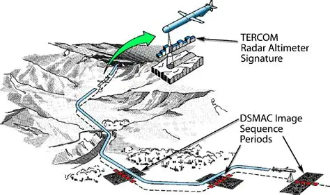
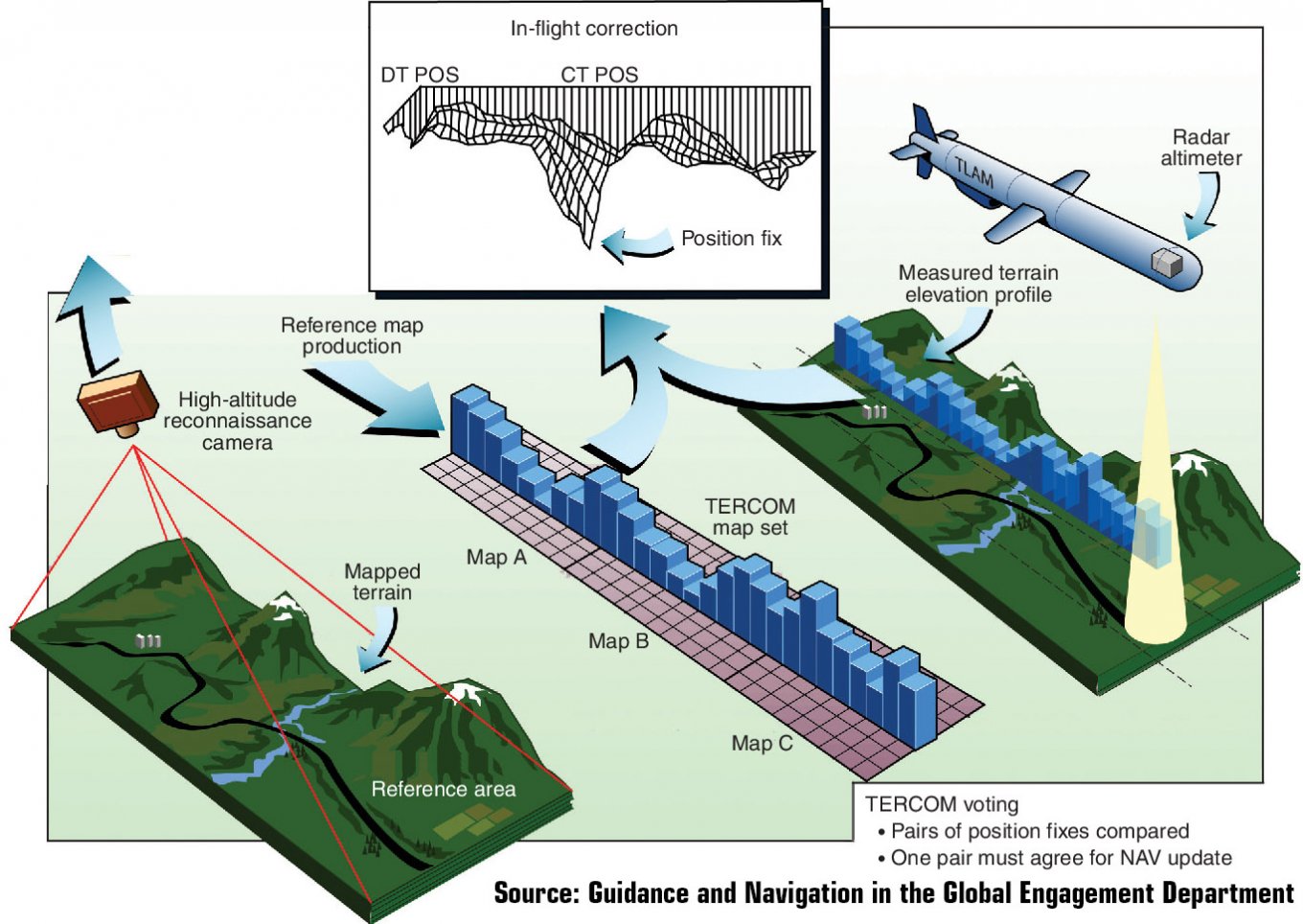
TERCOM is a way for a low-flying cruise missile to find out where it is by measuring the shape of the ground under it and comparing that shape to a map it already carries. The instrument is a downward radar altimeter. The map is a grid of stored elevations, usually built from satellite radar or survey data. The computer slides the measured strip across the stored grid until the hills and valleys line up. That match is a position fix. The inertial platform is then reset. The missile flies on.
It is not a seeker. It does not look at the target. It is a mid-course (and sometimes late-course) navigator for weapons that must stay low for hundreds of kilometres without talking to a satellite. Tomahawk made the name famous. Kh-55, 3M14 Kalibr, Iskander-K / 9M728-class land-attack rounds, Apache / SCALP cousins, and several other long-range cruise missiles use the same idea under local names. Combined with INS it is often called TAINS — terrain-aided inertial navigation.
WHY IT EXISTS
A free inertial platform drifts. A typical old cruise-missile INS wandered on the order of a nautical mile per hour. After a 1,500 km / two-hour hop that is kilometres of error — enough to miss a factory with a 450 kg warhead, enough even to fly into a ridge. Stellar fixes need a clear sky and altitude. Early radio updates can be jammed or reveal the shooter. GPS / GLONASS arrived later and can still be jammed or spoofed. TERCOM needs only a down-looking altimeter, a pre-loaded strip of Earth, and terrain that is not flat. It does not radiate forward. It does not need a satellite in view at the moment of the fix.
HOW A FIX IS MADE
Three steps, always the same.
1. Data preparation (before launch). Mission planners cut the route into “check areas.” Each area is a matrix of cells — squares of chosen size. Cell size is a memory-versus-accuracy trade: big cells save bits and give a coarse fix; small cells near the target cost memory and buy tens of metres. What is stored is not pretty-map altitude above sea level so much as the change from cell to cell. The radar altimeter measures clearance to the ground, not geoid height. A barometric or inertial vertical channel supplies the reference so the computer can turn clearance into a terrain profile.
2. Data acquisition (in flight). Over the planned patch the radar altimeter samples many times a second and fills a buffer with a ribbon of elevations along-track. The ribbon is a few kilometres long. Cross-track the search window must be wide enough to catch INS drift since the last fix.
3. Data correlation. The measured ribbon is compared with every down-track column of the stored matrix. Classic scores are mean absolute difference (MAD), mean square difference (MSD), or cross-correlation. The column with the best score is “you are here.” Along-track position comes from when the best score occurred. The autopilot gets a crosstrack and downtrack correction and the INS is zeroed for the next leg.
Early hardware quantized elevations into a handful of bits (four-bit maps appear in old U.S. notes — sixteen height bins). Modern mission cartridges hold finer grids. The algorithm does not care. Unique terrain does.
WHAT THE TERRAIN MUST DO
The ground under the ribbon has to have a fingerprint. Rolling hills, river valleys, ridgelines work. Open ocean does not. A salt flat does not. Seasonal sand dunes shift. Deep snow on taiga can hide or change the profile the map was built from. Foliage can fool a radar altimeter that was mapped to bare earth. Over water a 3M14 or Tomahawk flies on INS plus radar-altimeter height-hold only, then picks up TERCOM again when land returns. That is why Caspian-to-Syria tracks still needed mapped corridors over Iran and Iraq, not just a heading.
Altitude of the missile matters. Classic notes say correlation goes bad when radar height is more than about four or five cell-widths — the beam smears the cells together. Low cruise (tens to a few hundred metres) is where TERCOM is happy. It is also where the missile wanted to be anyway.
ACCURACY AND WHY DSMAC EXISTS
A good TERCOM fix is tens of metres to low hundreds of metres, depending on cell size, map quality, and how unique the ground is. That is enough to keep a nuclear Tomahawk or Kh-55 inside a city block. It is not enough for a conventional warhead on a bunker door. First-generation TERCOM weapons were therefore nuclear, or they needed another terminal trick.
DSMAC — Digital Scene Matching Area Correlation — is the optical cousin. A downward camera takes a picture. The computer turns it into a contrast map and matches that map to a stored satellite or reconnaissance image of the last few kilometres. Seasonal light and snow still hurt, but the fix can be small enough for a conventional point target. Tomahawk Block II onward stacked DSMAC on TERCOM. Russian 3M14 / Kh-101-class language uses the same stack: INS, satellite nav when available, terrain match, optical or radar scene match in the last stretch. Iskander-K cruise rounds are described the same way in open technical notes.
SITAN and later recursive filters (point-mass filters and the like) are the continuous cousins: instead of one batch match over a patch, they update the INS every sample. Same sensors. Different math. TERCOM is the batch name that stuck in missile handbooks.
TERCOM VERSUS SATELLITE NAV
GPS / GLONASS / BeiDou / Galileo give a fix anywhere, including ocean and desert, without a pre-loaded hill map, and they let a missile be retargeted late. They are faint. They can be jammed, spoofed, or denied over a theatre. TERCOM cannot be jammed from the side; the only radiating piece is a pencil beam pointed at the dirt. It cannot be given a brand-new target five minutes before launch unless that target already sits on a mapped corridor. A serious inventory therefore keeps both: satellite nav for flexibility against a weak enemy, terrain match for the day the sky is noisy. That is the sentence Wikipedia-era writing settled on, and it is still the right one.
WHO USES IT
United States: Tomahawk (TERCOM from the start; DSMAC later; GPS added; TERCOM retained). Soviet / Russian long-range cruise missiles: Kh-55 family, 3M14 Kalibr land-attack, air-launched Kh-101/102, and the Iskander-K / 9M728 land-attack cruise missile (see those articles). France and partners: Apache / SCALP / Storm Shadow class terrain-following weapons. Others fielded or studied the method for air-launched and ground-launched cruise missiles. Underwater vehicles use the same correlation idea against a bathymetry map; that is TERCOM’s cousin, not a missile.
WHAT IT IS NOT
It is not terrain-following radar that flies the missile up a valley in real time (TF radar is a different box, sometimes on the same airframe). It is not a radar seeker. It is not DSMAC. It is not GPS. It does not work as a sole navigator from a random park to a random building with no map-making first.
CAVEATS
Public accuracy figures (30–60 m, “tens of metres”) are order-of-magnitude handbook talk, not a released error budget. Map sources, cell sizes, and correlation tests for current Russian and American rounds are not in the open. Seasonal and foliage effects are real and are why mission planners still pick corridors instead of straight lines.
IN ONE SENTENCE
TERCOM is the cruise-missile trick of reading the hills with a radar altimeter and matching that strip to a stored elevation map so an inertial platform that has drifted can be told, without a satellite, where it actually is.