WHAT IT IS
An inertial navigation system measures how a vehicle accelerates and how it rotates, then integrates those measurements into velocity, position, and attitude without asking the outside world. The box that holds the sensors is the IMU — inertial measurement unit: three accelerometers and three gyros, one set per axis. The computer that turns those six numbers into a track is the INS. Nothing radiates. Nothing receives. If you start from a known point and a known heading, the machine can dead-reckon across an ocean, under ice, or through a jammed sky until its own errors grow larger than the mission can stand.
That is why every long-range cruise missile in the TERCOM and Kalibr articles starts with INS, why a Yasen or an Ohio can stay submerged for a patrol, and why an airliner still carries one when GPS is cheap. Satellite nav is a correction. Inertia is the spine.
THE TWO INSTRUMENTS
An accelerometer does not measure “speed.” It measures specific force: acceleration minus gravity, along one axis. Parked on the ramp it reads about 1 g upward (the table pushing back against weight). In free fall it reads zero. The navigator must therefore know which way is down, subtract the gravity model for that latitude and height, and only then integrate what is left into velocity, and integrate velocity into position. A 25 micro-g bias — navigation-grade — already produces a position wander that grows with time squared until other mechanics take over.
A gyroscope measures inertial angular rate. Old ones did it with a spinning wheel that wants to keep its axis fixed (Newton). Modern flight boxes do it with light: a ring laser gyro (RLG) or a fiber-optic gyro (FOG) watches the Sagnac phase difference between two beams running opposite ways around a closed path. MEMS gyros watch a vibrating proof mass and the Coriolis force on it. Hemispherical resonator gyros (HRG) watch a standing wave on a fused-quartz wine-glass. All of them output rotation. Integrate rotation and you have attitude — roll, pitch, heading — which is what lets the computer turn body-axis accelerometer readings into north, east, and down.
GIMBALLED VERSUS STRAPDOWN
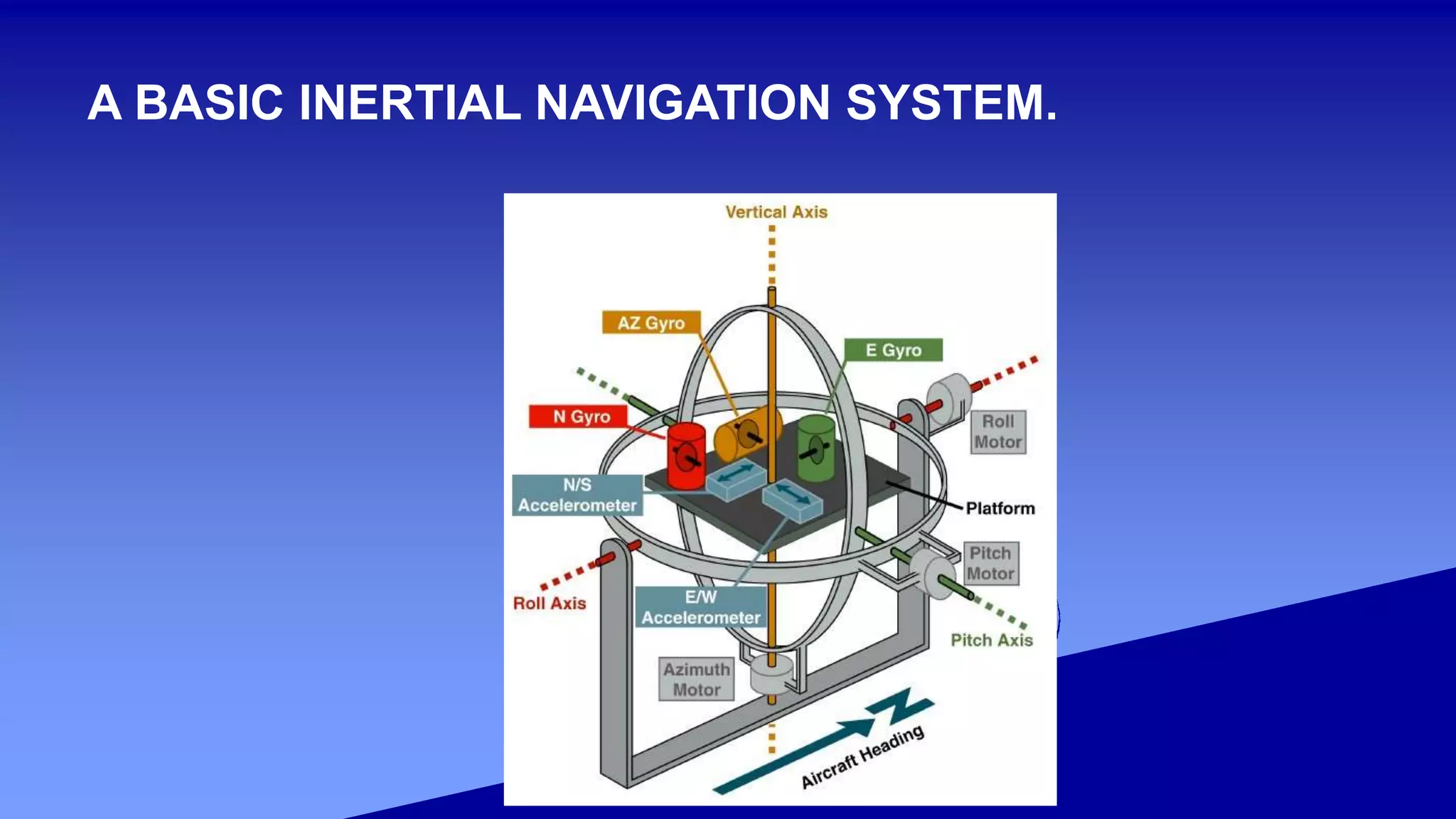
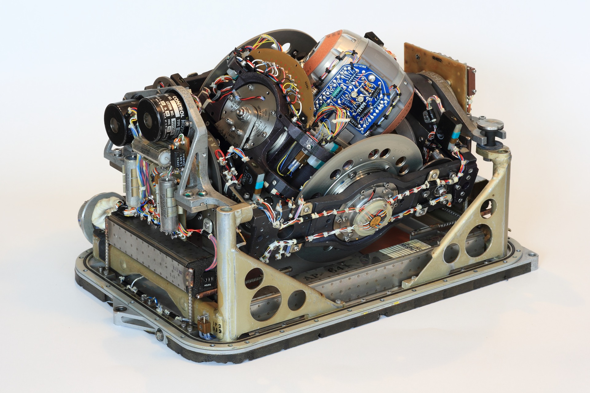
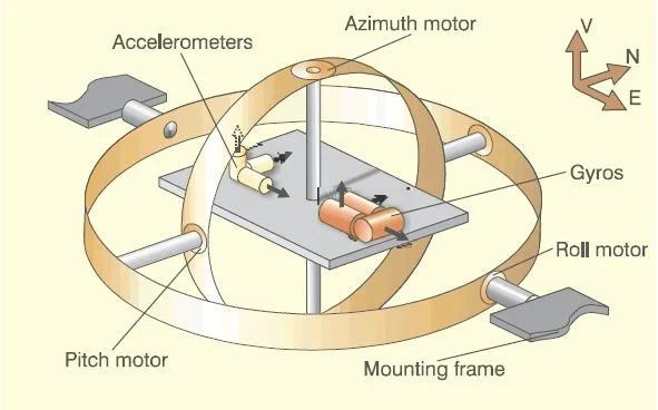
A gimballed INS puts the sensors on a stable platform hung in gimbals. Torque motors, steered by the gyros, keep that platform level and pointed north (or inertially fixed) while the airframe rolls around it. The accelerometers always sit in a nice navigation frame. The gyros see only Earth rate and the tiny commands that keep the platform honest. That is kind to spinning-mass instruments. It is heavy, it can gimbal-lock, it needs warm-up, and the mechanics wear.
A strapdown INS bolts the sensors to the vehicle. The gyros now see every roll rate of a fighter or a missile. The computer “rotates” the accelerometer vector into north-east-down in software, thousands of times a second. That demands scale-factor stability and high rate range from the gyros — which is why strapdown had to wait for RLGs in the 1970s. Almost every new aircraft, ship, submarine, and missile INS is strapdown. The platform did not get worse. The computers and the optical gyros got good enough to throw the gimbals away.
SCHULER TUNING — WHY ERRORS SWING, NOT RUN AWAY FOREVER
Move an accelerometer across a curved Earth and the local vertical tilts. If the platform (real or computed) does not tilt with it, the accelerometers start to smell a piece of gravity as a fake horizontal acceleration, invent a fake velocity, and walk off the map. Max Schuler’s 1923 pendulum period — the period of a plumb bob as long as the Earth’s radius — is about 84.4 minutes. An INS that is “Schuler tuned” applies a feedback so that a tilt error and the resulting velocity error exchange energy at that period instead of integrating to infinity. Position error then oscillates: a milliradian of tilt is already on the order of 6–10 km of peak position excursion half a Schuler cycle later. Gyro bias adds a slow walk of the oscillation’s centre. A 24-hour Earth-rate / Foucault component sits on top. That is why free-inertial accuracy is quoted in nautical miles per hour as a rough slope, even though the short-term picture is a swinging error, not a straight line.
Schuler tuning does not remove instrument error. It changes how that error appears. Uncompensated accelerometer bias sets the amplitude. Gyro drift sets how fast the mean position walks.
ALIGNMENT
Before the first metre of travel the system must know attitude. Coarse alignment uses accelerometers to find the vertical (leveling) and, on a stationary vehicle, gyros to find north by sensing Earth rate — gyrocompassing. That takes minutes on a navigation-grade box and does not work at the poles, where Earth-rate horizontal component vanishes. Fine alignment keeps running a Kalman filter on residual motion. A missile on a moving aircraft or a submarine that cannot sit still uses transfer alignment: it copies attitude and velocity from the mother ship’s INS while the two are bolted together, then flies.
A bad heading at launch is a built-in cross-track error that grows with distance. A bad tilt is a Schuler oscillation waiting to happen. Alignment is not a footnote. It is half the accuracy of the first hour.
SENSOR GRADES (ORDER OF MAGNITUDE)
These are handbook bins, not a contract specification. Gyro bias stability first, accelerometer second.
Consumer / automotive MEMS: worse than 1 deg/s class gyros, tens of mg accelerometers. Phones. Unusable alone after minutes. Tactical: about 1 deg/h and 1 mg. Short missiles, UAVs, AHRS. Free inertial for tens of minutes, not hours. Navigation: about 0.01 deg/h and tens of micro-g. Airliners, warships, cruise missiles. Roughly 1 nmi/h class free inertial when the rest of the error budget cooperates. Strategic: about 0.001 deg/h and micro-g. SSBN SINS, ICBM platforms, the quiet boxes that must hold a patrol. Position error after many hours still needs an occasional fix if the warhead is conventional and the target is small.
Published “CEP per hour” tables that print 1–10 m for RLG and kilometres for MEMS are useful as a ladder, not as a firing table. Real error is a mix of bias, scale factor, misalignment, vibration, temperature, and how violently the vehicle turns.
GYRO FAMILIES
Spinning-mass / floated integrating / dynamically tuned gyros (DTG): the Cold War workhorses. Gimbals loved them. They have g-sensitive drift. Warm-up and mechanical wear are real. Ring laser gyro: two laser beams in a triangular or square cavity; rotation shifts the interference fringe (Sagnac). Mechanical dither or a multioscillator scheme fights lock-in at low rates. Excellent scale-factor stability, almost no g-sensitivity, the sensor that made strapdown airliner INS ordinary from the late 1970s (Honeywell GG-series and cousins). Fiber-optic gyro: the same Sagnac idea in a coil of optical fiber. Cheaper path to tactical and navigation grades; coil temperature gradients are the classic headache. HRG: quartz hemisphere, very low noise, long life, strategic and space niches. MEMS: vibrating silicon. Cheap, small, g-sensitive, bias that ages. Fine in a phone or a short-life drone. Not a substitute for an RLG on an SSBN.
WHAT GROWS THE ERROR
Gyro bias → heading and tilt walk → Schuler and Earth-rate effects → position walk of order (Earth radius × gyro drift × time), plus the 84-minute swing. Accelerometer bias → fake acceleration → velocity ramp → Schuler oscillation whose size tracks the bias. Scale-factor error → every real turn or speed change writes a wrong increment. Strapdown fighters punish this. Misalignment of one sensor to another → the axes are not orthogonal in the computer’s head. Quantization and angle random walk → a noise floor that grows like the square root of time. Gravity-model error and deflection of the vertical → the computer subtracted the wrong “down.”
None of these need an enemy. They run on a quiet bench.
AIDING — WHY TERCOM AND GPS EXIST
A pure INS is a clock that cannot be wound from outside. Aiding is any independent measurement that the Kalman filter uses to estimate and bleed off those states.
GPS / GLONASS / Galileo / BeiDou: position and velocity, anywhere including ocean. Jammable, spoofable, faint. TERCOM: radar-altimeter terrain strip versus a stored map. Works without a satellite; needs hills. Covered in its own article. DSMAC: optical scene match for the last kilometres. Baro-altimeter: damps vertical channel (the vertical INS loop is not Schuler-stable in the same way; unaided height diverges fast). Doppler velocity log / EM log / odometer: ships and land vehicles. Star trackers: missiles and spacecraft that can look up. Transfer alignment and zero-velocity updates: the cheap tricks — sit still, or copy mother.
A Tomahawk, a 3M14 Kalibr, or a Kh-101 is therefore not “an INS missile” or “a GPS missile.” It is an INS that is reset by whatever the route and the threat allow. Kill the satellites and TERCOM still has a job. Fly over water and TERCOM waits. That stack is the whole point of the last three articles in this set.
WHERE IT LIVES
Aircraft: strapdown RLG or FOG IRS (inertial reference system) as the attitude and navigation core, GPS-aided. Cruise missiles: compact tactical-to-navigation IMU plus TERCOM / GNSS / DSMAC. Drift of order 0.8–1.5 nmi/h is the historical cruise-missile sentence; modern aided systems do better until the aid is denied. Ballistic missiles: platform or strapdown of strategic grade; the boost is short, the demand is attitude and cutoff velocity, not a two-hour Schuler story. Submarines: SINS. Polaris was not a patrol boat until Draper and Autonetics could hold a mile-class error without surfacing. Still the reason a boat can give a missile a launch position under ice. Ships, tanks, survey, spacecraft: same physics, different grades and different aids.
WHAT IT IS NOT
It is not GPS. It is not a compass (a magnetic compass measures a field; a gyrocompass measures Earth rate). It is not TERCOM. It does not know where it is at switch-on. It cannot hold height unaided. “Inertial guidance” on a short ATGM is often just a mid-course attitude reference, not a full navigator.
CAVEATS ON THE NUMBERS
Deg/hour and nmi/hour are marketing bins. A 0.01 deg/h gyro in a badly aligned, hot, vibrating strapdown box will not deliver a 1 nmi/h INS. Quantum and cold-atom instruments exist in labs; they are not the fleet IMU on a Buyan-M. Treat every published CEP-per-hour table as a ladder.
STATUS
Universal. The only navigation that still works when the sky is denied, the map is flat, and the radio is dead — until time runs out. Everything else in the guidance stack is there to buy that time back.
IN ONE SENTENCE
An INS is three gyros and three accelerometers plus a computer that integrates rotation and specific force into a track — unaided, silent, and slowly wrong — which is why cruise missiles, SSBNs, and airliners all start there and then bolt on GPS, TERCOM, or a star if they can get one.