WHAT THEY ARE
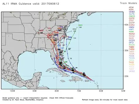
A hurricane model is a computer forecast of a tropical cyclone, not a warning. The National Hurricane Center (NHC) reads a stack of them and writes the official track, intensity, and wind-radii forecast. No single model is that forecast. Consensus of the better members beats most individuals. The public “spaghetti plot” is the set of those tracks drawn on one map.
Two questions are separate. Track is where the center goes. Intensity is how strong the wind gets, including rapid intensification. A model can be good at one and poor at the other. Global models have historically led on track. Regional hurricane models and statistical-dynamical schemes have carried intensity.
HOW A DYNAMICAL MODEL WORKS
The atmosphere is cut into a grid. Each cell holds wind, temperature, moisture, and pressure. The model steps the primitive equations forward in time: conservation of momentum, mass, energy, and water. A dynamical core does that arithmetic. Parameterizations stand in for processes smaller than a cell — convection, clouds, radiation, turbulence, surface friction.
Data assimilation builds the starting state. Satellites, radiosondes, aircraft, dropsondes, buoys, and scatterometers are blended with a short forecast so the grid is not empty. A bad initial vortex is a bad forecast even with good physics.
A hurricane is small relative to the globe. Global models run a cell of order 9–13 km. Regional hurricane models put a moving nest of about 2 km over the storm so the eyewall can exist as more than one grid point, and couple the atmosphere to an ocean model. Coupling matters because a slow storm stirs cold water to the surface and caps its own intensity. Wave coupling adds the sea state under the wind field.
OTHER KINDS
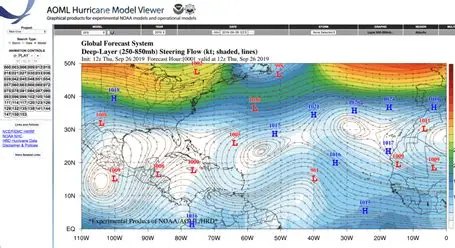
Trajectory models (BAM, Beta and Advection) do not simulate the storm. They advect a point vortex in the steering flow taken from a global model, plus a beta-drift term. Early, cheap track aids. Shallow, medium, and deep versions (BAMS, BAMM, BAMD) sample different layers.
Statistical-dynamical intensity models do not integrate the fluid equations for the vortex. SHIPS regresses intensity change on climatology, persistence, and environmental predictors taken from a dynamical run (shear, humidity, sea-surface temperature, ocean heat content). LGEM uses a subset of those predictors inside a logistic growth equation bounded by maximum potential intensity. DSHP is SHIPS with inland decay. They are fast and have often beaten pure dynamical intensity guidance.
Ensembles rerun one model from perturbed starts, usually at coarser grid spacing. Spread is the uncertainty. GEFS is the GFS ensemble (31 members). The ECMWF ensemble (ENS) has 51. A tight cluster is not a guarantee. It means that model’s assumptions agree with themselves.
Consensus averages selected members. TVCN is the variable track consensus. Intensity consensus blends the intensity aids. Simple averaging of good models is why the official forecast usually beats any one line on the plot.
AI / machine-learning models (AIFS / AI-Euro, GraphCast-class, AIGFS and others) are trained to imitate analysis and forecast fields. By the mid-2020s they were on NHC comparison plots. They are not a fluid solver. Skill is real on track in some seasons and not a replacement for the official forecast.
GLOBAL MODELS
These forecast the whole atmosphere. A tracker then finds the cyclone in the wind field.
GFS (NOAA Global Forecast System, ATCF AVNO/GFSO). FV3 dynamical core on a cubed sphere, hybrid vertical coordinate, hybrid ensemble-variational assimilation. Runs four times a day. Primary U.S. global track input. GEFS is its ensemble.
ECMWF / IFS (“Euro”, EMXI). European Centre for Medium-Range Weather Forecasts. Long the reference global track model. Ensemble of 51. Deterministic run is higher resolution than the members.
UKMET (EGRI / UKM). Met Office global model. Independent middle member. Useful when GFS and ECMWF diverge.
CMC / GEM (Canadian Global Environmental Multiscale). Fourth global often on the consensus plot.
NAVGM (U.S. Navy global, successor to NOGAPS). Navy track input, paired with the Navy regional COAMPS-TC (CTCX).
REGIONAL HURRICANE MODELS
These are started only when a storm exists or is expected. The nest follows the vortex.
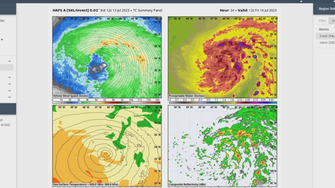
HAFS (Hurricane Analysis and Forecast System). NOAA operational regional system from 27 June 2023. FV3 core, same family as GFS, so the start is unified with the global model. Storm-following nest near 2 km inside a coarser parent, coupled to HYCOM ocean; one configuration also one-way to WaveWatch III. Two ops configs: HAFS-A (HFSA, replaced the HWRF role, more basins) and HAFS-B (HFSB, replaced the HMON role, NHC basins). Inner-core assimilation and vortex initialization. Design targets are track, intensity including rapid intensification, size, genesis, rain, and surge. NOAA’s pre-operational retros claimed about 10–15% track gain on the older regional pair and better rapid-intensification hits.
HWRF (Hurricane Weather Research and Forecast). The previous NOAA flagship regional model. Coupled, moving nest, workhorse of the Hurricane Forecast Improvement Program. Superseded in role by HAFS-A. Still named on some guidance plots into the mid-2020s while the transition finished.
HMON (Hurricanes in a Multi-scale Ocean-coupled Non-hydrostatic model). Second NOAA regional, different physics, so the pair was not two copies of one model. Role passed to HAFS-B.
GFDL. The 1990s–2000s regional predecessor of HWRF. Retired from operations. The laboratory still builds cores used downstream.
COAMPS-TC. Naval Research Laboratory coupled tropical-cyclone model. Navy intensity and track aid, especially outside the Atlantic.
INTENSITY AIDS
SHIPS (Statistical Hurricane Intensity Prediction Scheme) and LGEM (Logistic Growth Equation Model) are the standing statistical-dynamical pair. Decay-SHIPS handles land. Dynamical intensity comes from HAFS, HWRF/HMON while they ran, and COAMPS-TC. Rapid intensification remains the hard problem: a 30-knot gain in 24 hours is a tail of the distribution, and models that get the shear and the ocean heat content wrong miss it together.
WHAT THE NHC ACTUALLY DOES
Forecasters compare early and late cycle runs (a “late” model arrives after the advisory deadline and is interpolated forward as an early aid). They down-weight a model that has been consistently off on that storm. They do not pick the scariest line. Official track error has fallen for decades mainly because global models and consensus improved. Intensity error fell more slowly, which is why the regional nest and the ocean coupling exist.
NOT THESE
A Facebook model collage is not an NHC product.
The cone of uncertainty is an average historical error around the official track, not the envelope of every model on the plot.
A single HAFS run is not the warning.
Climatology (where storms usually go in that month) is a baseline, not a forecast.
CAVEATS
Names and resolutions change every upgrade cycle. HAFS-A/B physics suites are not identical. Skill rankings flip by basin and by year. HWRF and HMON remained visible in public guidance after HAFS became operational; treat a current plot, not this page, as the live roster.
STATUS
Operational. HAFS is NOAA’s regional hurricane system from the 2023 season. GFS, ECMWF, UKMET, CMC, GEFS, SHIPS, and LGEM remain the standing global and statistical set.
IN ONE SENTENCE
Hurricane models are a stack — global dynamical track models (GFS, ECMWF, UKMET, CMC), a storm-following regional system (HAFS, heir to HWRF and HMON), statistical intensity aids (SHIPS, LGEM), and ensembles — which NHC averages and corrects, because no one grid is the forecast.